Log in
All resources
Create a design
2,542 Free Artworks of Maps Of Paris
bibliothèque nationale de france
sanson maps of asia
maps from gallica
guides joanne
map of europe by nicolas and guillaume sanson (1669)
nouvelle géographie universelle, vol. xvi
géographie générale; physique, politique et économique (1876)
guillaume sanson
nouvelle géographie universelle, vol. viii
nouvelle géographie universelle, vol. xiii
sanson maps of the circles of germany
1670s maps of baden-württemberg
nouvelle géographie universelle
1887 maps of africa
le royaume de france distingué by guillaume sanson
1724 maps of france
maps from gallica
guides joanne
1667 map of madagascar by guillaume sanson
bibliothèque nationale de france
map of the circle of franconia by sanson
1680s maps of bavaria
le royaume de france distingué by guillaume sanson
1724 maps of france
maps of the arctic ocean
maps of the north pole
lettres sur la morée (1808)
maps of monemvasia
nieuwe en beknopte hand-atlas (1754)
le royaume de france distingué by guillaume sanson
maps by nicolas sanson
map of the upper rhenian circle by sanson
1700s maps of north rhine-westphalia
album met 345 prenten van hogenberg
maps in the rijksmuseum amsterdam
cartouche (cartography)
jean-claude dezauche
old maps of the kingdom of naples
1700s maps of italy
maps by nicolas sanson
guillaume sanson
nouvelle géographie universelle, vol. viii
maps of gwalior
nouvelle géographie universelle, vol. xiii
maps of congo
pierre alexander tardieu
delaval (surname)
maps from gallica
guides joanne
mappe-monde geo-hydrographique (sanson and jaillot, 1674)
bibliothèque nationale de france
philippe de la rué
périgord
pierre antoine tardieu
françois houiste
considérations géographiques et physiques sur les nouvelles découvertes au nord de la grande mer
isla de los estados
considérations géographiques et physiques sur les nouvelles découvertes au nord de la grande mer
eso island
considérations géographiques et physiques sur les nouvelles découvertes au nord de la grande mer
eso island
architectural drawings of luxembourg palace
proletarian literature
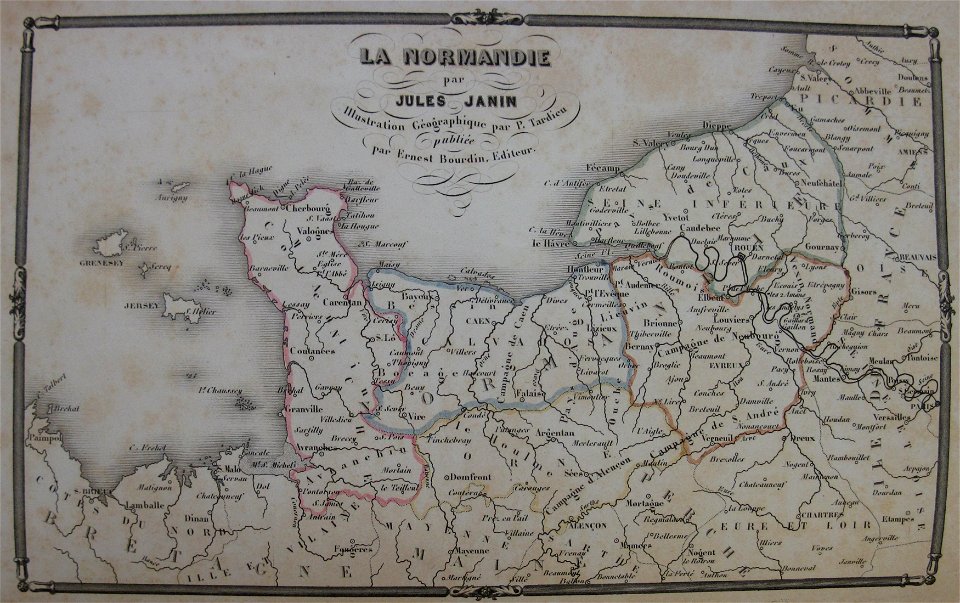
19th-century maps of normandie
la normandie (jules janin)
bibliothèque nationale de france
sanson maps of asia
bibliothèque nationale de france
sanson maps of asia
map of europe by guillaume sanson (1674)
bibliothèque nationale de france
sanson maps of the circles of germany
bibliothèque nationale de france
map of europe by guillaume sanson (1674)
bibliothèque nationale de france
beschreibung der städt der welt - braun & hogenberg - btv1b52512111k
maps of paris by braun & hogenberg
bibliothèque nationale de france
sanson maps of asia
sanson maps of the circles of germany
bibliothèque nationale de france
bibliothèque nationale de france
sanson maps of asia
engravings in musée carnavalet
charles simonneau
1680s maps of rhineland-palatinate
maps of vangiones by sanson
map of italy by guillaume delisle (1700)
bibliothèque nationale de france
maps with azimuthal equidistant projection
french-language maps of antarctica
19th-century maps of sumatra
mount ophir
1876 maps of south america
southern cone
géographie générale; physique, politique et économique (1876)
basses-pyrénées
maps from gallica
guides joanne
cascade d'enfer (haute-garonne) in art
pierre gorse
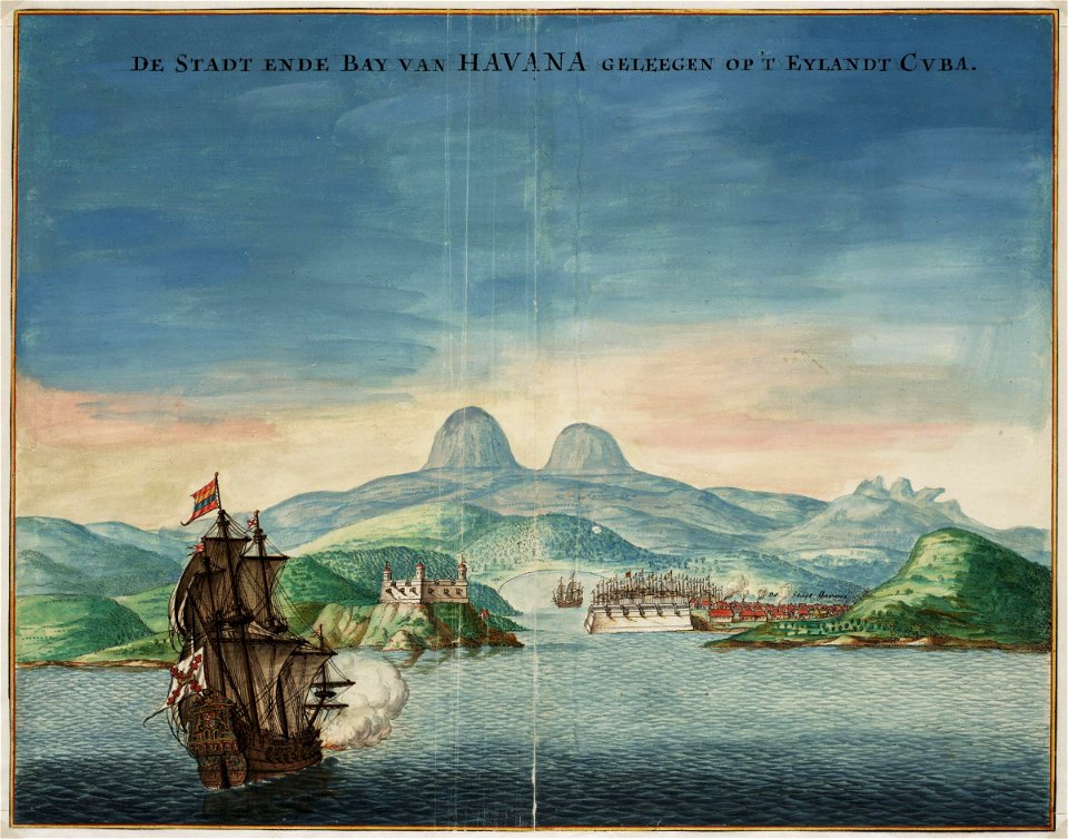
old maps of havana
1665 maps
waterfalls in haute-garonne
bagnères-de-luchon in art
lac d'oô in art
pierre gorse
old maps of norway
guillaume sanson
maps by nicolas sanson
red ruthenia
bibliothèque nationale de france
sanson maps of north america
map of europe by nicolas and guillaume sanson (1669)
bibliothèque nationale de france
map of europe by nicolas and guillaume sanson (1669)
bibliothèque nationale de france
maps of italy by sanson and cordier
bibliothèque nationale de france
map of europe by nicolas and guillaume sanson (1669)
bibliothèque nationale de france
bibliothèque nationale de france
sanson maps of asia
maps of italy by sanson and cordier
bibliothèque nationale de france
maps from gallica
guides joanne
bibliothèque nationale de france
sanson maps of asia
maps from gallica
guides joanne
map of the circle of austria by sanson
context files from gallica
bibliothèque nationale de france
sanson maps of asia
map of europe by nicolas and guillaume sanson (1669)
bibliothèque nationale de france
map of europe by nicolas and guillaume sanson (1669)
bibliothèque nationale de france
map of europe by nicolas and guillaume sanson (1669)
bibliothèque nationale de france
map of europe by guillaume sanson (1674)
guillaume sanson
maps from gallica
guides joanne
bibliothèque nationale de france
sanson maps of asia
old maps of brabant
guillaume sanson
old maps of the franco-prussian war
alfred quesnay de beaurepaire
maps from gallica
guides joanne
old maps of saint-louis (senegal)
orientalist painting
le sénégal. la france dans l'afrique occidentale (1889)
orientalist painting
orientalist painting
old maps of dakar
nouvelle géographie universelle, vol. xiii
19th-century maps of tanzania
nouvelle géographie universelle, vol. viii
1876 maps of india
nouvelle géographie universelle, vol. xvi
1876 maps of philadelphia
nouvelle géographie universelle, vol. vi
1870s maps of armenia
nouvelle géographie universelle, vol. xvi
1870s maps of colombia
nouvelle géographie universelle, vol. viii
1876 maps of india
nouvelle géographie universelle, vol. xvi
old maps of new haven, connecticut
nouvelle géographie universelle, vol. xiii
1876 maps of africa
nouvelle géographie universelle, vol. xvi
maps of education in the united states
nouvelle géographie universelle, vol. ix
1870s maps of iran
nouvelle géographie universelle, vol. xvii
maps of texcoco lake, mexico
nouvelle géographie universelle, vol. xvi
1876 maps of the united states
nouvelle géographie universelle, vol. xii
old maps of santo antão (cape verde)
nouvelle géographie universelle, vol. xiii
old maps of gabon
nouvelle géographie universelle, vol. vi
maps of aral sea
nouvelle géographie universelle, vol. xii
old maps of tenerife
nouvelle géographie universelle, vol. viii
1870s maps of india
nouvelle géographie universelle, vol. vi
maps of lakes of russia
nouvelle géographie universelle, vol. xvi
old maps of newport, rhode island
beschreibung und contrafactur der vornembster stät der welt, liber primus civitates orbis terrarum
maps of paris by braun & hogenberg
18th-century maps of the aegean sea
jean-fréderic phélypeaux
voyages de la commission scientifique du nord, en scandinavie, en laponie, au spitzberg et aux feröe
maps of bossekop
voyages de la commission scientifique du nord, en scandinavie, en laponie, au spitzberg et aux feröe
maps of bossekop
palais royal (1634–1763)
gilles-marie oppenord
1690s maps of rhineland-palatinate
maps of east palatinate by sanson
1301 - 1400 of 2,542
Next page
/ 26